

Regional or area maps are a good way to drill down from provincial maps and provided added geographic details and more settlements, especially given my avoidance of maps with too much clutter. These regional maps span the spectrum from provincial maps to those detailing towns and villages.
Regional maps are organized by Imperial provinces, city-states (Stadtstaaten), or the major river arteries of the Empire. In some cases, the regional map may include portions of other provinces for completeness sake, but I have chosen to place such maps within the province I considered the major portion lies. In other cases, more detailed maps are placed with the major river valleys where they reside and are placed from downriver to upriver for ease of use.
West Aver Valley region
This regional map represents the Western Aver Valley and its watershed, which includes the parts of the northwestern Averland and southwestern Stirland along the River Aver. The map was created for the still-in-progress Streissen sourcebook.
County of Gagern
Gagern is a county in Averland with Streissen as its largest town and seat of power. The map was created for the still-in-progress Streissen sourcebook.
Stadtstaat of Middenheim.
This map covers the area surrounding Middenheim and differs a bit from the one appearing in the "Middenheim: City of Chaos" sourcebook.
Staatstadt of Nuln
Like the Altdorf map, this covers the area surrounding Nuln.
Altdorf and nearby villages
This map covers the area around Altdorf, including its villages.
Reikland, southern region
The map of the southern portion of Reikland was created for the "The Gathering Darkness: Conquering Darkness" adventure. It differs from the map that appeared in WFRP1e "Death on the Reik" publication in that I tried to remain consistent with the Empire map from the corebook. Most of the villages from the DotR book appear on this map and all are listed in the Reikland gazetteer. Cubicle 7 further developed the area with the release of 4th edition WFRP and rendered my version obsolete.
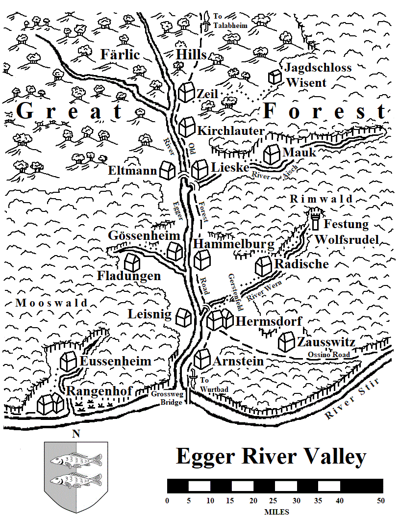
Egger River Valley
Egger River Valley is located in the south-central region of Talabecland and encompasses the Old Forest Road from River Stir to the southern edge of the Färlic Hills. This map was developed for my 2018-2023 WFRP campaign set in the 2513-2514 Empire. The region was once the Duchy of Eggertal, but was broken up in the mid-18th century into the Baronies of Drugen (area around Hermsdorf) and Waizen (area around Lieske).
Revised 26 December 2023. Added Grossweg Bridge to the map from 2nd edition "Sigmar's Heirs" as well as two new locations in the Rimwald.
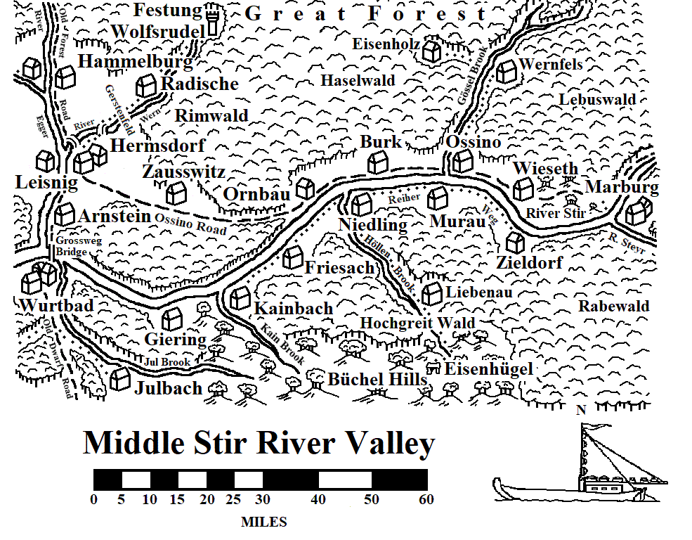
Middle Stir River Valley
Middle Stir River Valley is the stretch of the Stir from Wurtbad to Marburg, though I opted to not include the portion of the Talabeclander side which appears in the Egger river Valley map. This map was developed for my 2018-2023 WFRP campaign set in the 2513-2514 Empire. I haven't as yet developed any details of this area (though I have a project to do just that).
Revised 29 December 2023. Added the portion of the Egger River Valley map that overlaps with the original Middle Stir River Valley to provide a more complete view of this stretch of the Stir River Valley.
Hundsheimer Wald region
Revised 10 March 2019. This map was drawn for the 2018-2023 campaign I ran. It incorporates the area that Natascha Chrobok described in her "Monastic Orders in the Old World" sourcebook (though I did expand the distances between settlements). This map also adds a few more settlements to the area around Zipf which was described by Henrik Grönberg's "Zipf and the Leithag March" manuscript, which can be found at the Liber Fanatica Apocrypha page.
Revised 25 June 2020. Added new Talabecland settlement (Roth) while changing the name of another (from Tauer to Aufsess).
Revised 25 November 2023. Added settlements to the west and east of the Hundsheimer Wald region that appeared on adjacen regional maps I drew.
County of Schirach
Schirach is a county in the easternmost area in Talabecland. This map was developed for my 2018-2023 WFRP campaign set in the 2513-2514 Empire. Krugenheim is the largest town in this region of the River Stir and the seat of the county. Update 26 October 2020: Change the name of the area between Kolsa Hills (Talabecland) and Bleak Moors (Ostermark) from Feuchtermoor to Gundel Plain.
Revised 25 June 2020. Changed some names and added a new village.
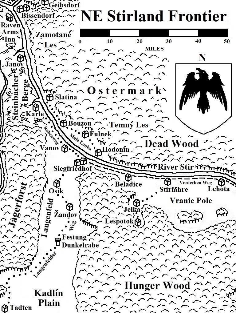
NE Stirland Frontier
NE Stirland Frontier is the region where Stirland, Sylvania, and Ostermark meet and the Raven Knights of Siegfriedhof maintain their watch over one of the invasion routes used by the Vampire Counts of old. The region is known for its dark and dangerous woodlands. Yet, there are people who have lived in the region for millennia still eking out their existence from the land. Revised 7 February 2023.
Pfeildorf and Barony of Toppenheim
This map that covers the villages near Pfeildorf, once the capital of Sudenland.
Sudenland, central region
This map was drawn for "The Gathering Darkness: Grim Pursuits" scenario. It includes many of the settlements in the central portion of Sudenland.
Sudenland, eastern region
This map has been created for the forthcoming Wissenland sourcebook. It includes many of the settlements in the eastern portion of Sudenland.
Sudenland, northern region
This map was drawn for "The Gathering Darkness: Grim Pursuits" adventure. It includes many of the settlements in the northern portion of Sudenland.
Staatstadt of Talabheim
This map covers the area of the Staatstadt of Talabheim and is consistent with the map in Warpstone. It differs from the one appearing in Green Ronin's "Terror in Talabheim" adventure book.
Wissenland, central region
Like the other regional maps of the province, the map of the northern portion of Wissenland was developed for "The Gathering Darkness: Conquering Darkness" scenario. It includes a number of newly listed settlements in the central portion of the province.
Wissenland, northern region
The map of the northern portion of Wissenland was drawn for "The Gathering Darkness: Conquering Darkness" adventure. It includes many of the settlements in the central portion of the province as well as the Dwarf settlements in the Grey Mountains.
Wissenland, southern region
This map was created for "The Gathering Darkness: Conquering Darkness" scenario. It includes many of the settlements in the southern portion of Wissenland.